Newminster Abbey
Morpeth
Last Updated:
13 Oct 2024
Morpeth
55.166489, -1.704490
Site Type:
Abbey, Place of Worship
Origin:
Status:
Partly Preserved
Designer (if known):
Robert of Newminster
Listed Grade II

This cluster of trees just outside Morpeth conceals one of the most important religious sites in the whole of Northumberland.
This is the site of Newminster Abbey, a 12th century Cistercian abbey. It was founded by the Lord of Morpeth Ranulph de Merlay and his wife Juliana, who was daughter of the Earl of Lothian. They appointed Robert, the founder of Fountains Abbey, to establish this one close by to Ranulph’s Castle against the Wansbeck.
Though encountering turbulent times, including the razing of the original timber structures by Scottish raiders a year into its life, it became one of the strongest ecclesiastical strongholds in the region. They held fisheries on the Tyne, salt pans at Cambois and extensive pasture lands across the Northumberland countryside. Their influence led to the establishment of the network of daughter houses - Pipewell in Northamptonshire, Roche Abbey in Yorkshire, Sawley Abbey and countless granges across the country.
The Abbey officially dissolved in 1537, and was mostly lost and forgotten until the 19th century. After that, the land was leased by the Crown to the Greys who reclaimed the stone for many of their own buildings. It was later sold to the Brandlings in 1609 and thereon the Ords of Fenham, a collection of well known northern surnames. All that featured by the 19th century was a singular arch on the hill - a standing reminder of a once mighty religious stronghold. It was painted extensively, but there was known to be extensive remains under the surface. There was excavations in the early 20th century revealing extensive masonry, silver coins and artefacts.
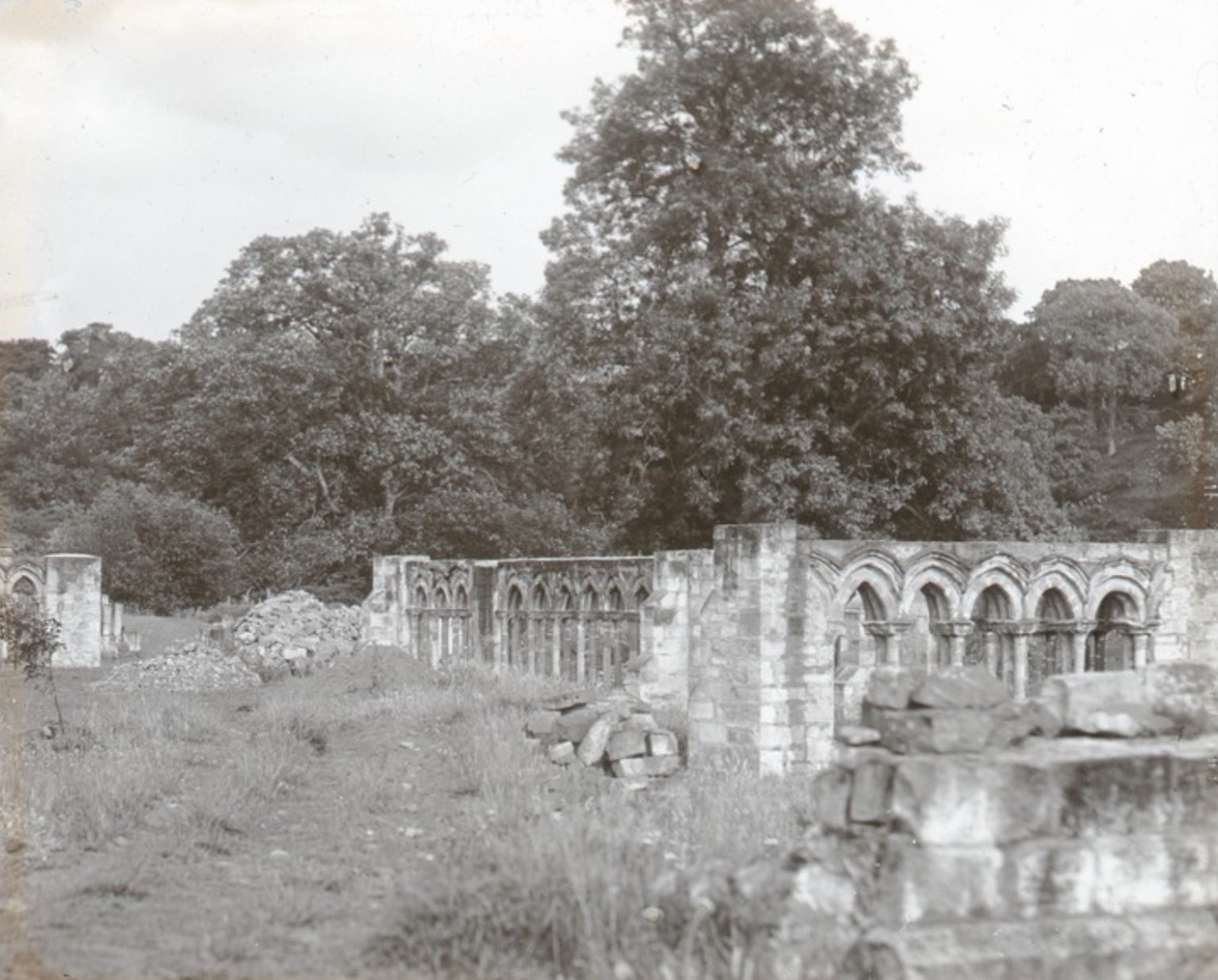
George Renwick, the MP for Newcastle and owner of the Tyne Pontoons & Dry Dock Co. at Wallsend, actually partially rebuilt the Abbey. The excavated cloisters, chapter house and other bits of masonry were amateurishly re-placed as a kind of folly, ornamental garden as you can see on the photographs below.
They still stand, but covered over by the dense foliage. The land is totally private, and that includes the extensive remains still buried. Tiled pavements, an infirmary hall, a lay brothers range and a dorter all still remain in the undergrowth here around plenty of ridge and furrow.
Notably the waters of Abbey Well, just on the south end of the site, provided the brand for Abbey Well owned by Coca-Cola. It remains to be bottled in Morpeth, and is the only Coca-Cola water site in the UK.
Listing Description


The maps shown illustrate the Newminster Abbey site from the 1850s to the 1890s. The mid 19th century map shows the extensive earthworks before any of the abbey was excavated and re-placed. The Abbey Well was still flowing, but the site was relatively untouched. The surrounding land was pasture & agriculture, with much of it now developed for housing.
The 1890s map provides further detail of the extensive earthworks as well as what was standing at the time. The archway looks like have been at the centre of the site, and the outlines of various walls are documented. Spring Hill Farm, a now demolished farmstead with two separate wells stand to the east, and Newminster Cottage & Abbey Kennels stand to the north west. It's clear the Abbey provided the collective identity of this area many centuries after abandonment.

This map provides us the clearest view of where the masonry was re-placed in the 20th century. Every single element of this can't be seen from the outside thanks to the dense vegetation (I've scanned my photos for a while now...), but it's still interesting to see just how much was lifted from the undergrowth. To only supplement Renwick's "ecclesiastical theme park", he redug the Abbey fish pond though this has since dried up.

Site of Newminster Abbey in August 2024. There are extensive earthworks surrounding the main complex within the undergrowth. From this perspective, archaeological examinations have found medieval ridge & furrow and even lynchet's (earth terraces) dug to maximise use of land on a steep slope.

An early view of Renwick’s reconstruction of the cloisters by Godfrey Bingley (1842-1927). Godfrey Bingley Photographic Archive MS1788/60/52 ©University of Leeds. Originally shared by The Folly Flaneuse: https://thefollyflaneuse.com/newminster-abbey-morpeth-northumberland/

The singular arch still standing before re-placement in the early 20th century