top of page

Mitford, Northumberland

Mitford Castle

Last Updated:

17 Oct 2024

Mitford, Northumberland

This is a

Castle

55.162975, -1.733957

Founded in 

12th century

Current status is

Ruined

Designer (if known):

4076554724_b6df6c95d4.jpg

Scheduled Monument

What a pleasure it was to visit Mitford in the glorious Northumberland sunshine. The biggest attraction of all - the remains of its castle, perched upon its mound.

The first mention of this site is back in 1138, a few decades after the village was granted a market charter - one of the first above the Tyne. The first known occupier was William Bertram, of Norman descent whose family was gifted this land by William the Conqueror through marriage to Sybilla Mitford. His family went on to continue developing and extending this land, and it was this family who invited monks from Norfolk to found Brinkburn Priory.

It was later occupied by William the Lion in 1175 after the Battle of Alnwick and before he swore fealty to Henry II. By 1215 it was confiscated by King John, and only 2 years after that an attempt to hijack it occurred again by the Scots in 1217, and only went to happen again in 1318. Given the extent of damage and ruin, it was described as abandoned and "wholly burnt" a few years after.

Much of what we see today is from the following centuries. We find the remains of a motte & bailey, a shell keep castle and remains of a medieval chapel & graveyard on the right of my photos. In fact, some headstones still feature at the site. The field in front features extensive ridge & furrow and a hollow way. This led to a sandstone quarry, which is very certainly the source of the building we see today.

It didn't even have a long life as a keep. It was held by Roger Bertram III but seized and transferred to the 1st Earl of Pembroke. The Balliol's had it, then the Lilburn's and Middleton's in the early 14th century. In 1315, the Bishop of Durham and 2 Italian cardinals were imprisoned here. This may have also been when the castle was destroyed, and was certainly in ruins by 1323.

Most recently it was purchased from the Mitford's by the Shepherd's, who also owned Newcastle United in the 90s. Work continues to preserve and understand this site

Here's a clipped excerpt from the Alnwick Mercury of 02/02/1857:

"The castle was probably built soon after the conquest, though neither the exact time nor the name of the builder has reached us. At the Conquest, Mitford is said to have been the lordship of Sir John Mitford whose only daughter Sybil married Roger Bertram.

The castle stands in a park not far from the river Wansbeck, and is elevated on a mount seemingly artificial. Very little of it is remaining; it never having been repaired since its destruction by the Scots in the time of King Edward II.

The principal part of this fortress consisted of a circular tower raised upon an artificial mount, the chief elevation from the natural level being effected by arches of stone and vaults, which in ancient times were used as prisons or places of concealment. The tower was defended by an outward wall, which ran parallel of about 10ft."

Listing Description (if available)

The monument includes the remains of a motte and bailey and shell keep castle and parts of a medieval chapel and graveyard, situated in a prominent position on the summit of a hillock above the River Wansbeck to the north and the Park Burn on all other sides; part of a medieval field system is situated at the northern foot of the hillock. The shell keep castle, the stone walls of the outer ward and associated structures, the remains of the chapel and two medieval headstones are Listed Buildings Grade I. An adjacent World War II pill box is the subject of a separate scheduling. Mitford Castle was first mentioned in 1138 when it was referred to as the `oppidum' of William Bertram, and it is known to have been occupied by William the Lion in 1175. It was confiscated by King John in 1215 and attacked unsuccessfully by the Scots in 1217. In 1317 the castle became the headquarters of Sir Gilbert Middleton but was captured and occupied by the Scots in 1318. By 1323 the castle was reported as being so damaged that it had to be abandoned. In 1327 it was described as being `wholly burnt'. The motte, later occupied by a shell keep, is visible as a substantial earthen mound measuring 56m north east to south west by 34m, situated at the centre of the north west edge of the knoll. There are traces of a surrounding ditch visible on its northern side. An oval bailey, situated to the south and south east of the motte, occupies the entire summit of the hill and measures 150m north east to south west by 75m north west to south east. The southern half of this bailey was later enclosed by a curtain wall to create an outer ward associated with the shell keep; the northern half of the bailey was retained as an undefended barmkin with an earthen bank between 1m to 2m wide and standing 0.4m high around its edge. On the lower ground to the north and south, the bailey is defended by a series of outworks; on the south west sides these include a ditch 10m wide and up to 2m deep with a flanking counterscarp bank. A similar ditch exists on the south eastern side where it has been disturbed by later quarrying which has also removed a section from the southern part of the bailey. On the north western side, the outworks include a triangular shaped platform and an outer moat a maximum of 1m deep. A `D'-shaped shell keep was constructed around the perimeter of the motte during the 12th century, creating an inner ward. The west wall and part of the east wall of the shell keep, which are constructed of high quality squared stone, are visible, each containing the remains of an arched entrance. Within the interior of the shell keep there are the remains of a central tower of early 13th century date. The tower is visible as the lower courses of a five sided stone building which measures 11m square with walls 2m thick. The basement of the tower is divided by a wall into two chambers, each with a barrel vault. These chambers are thought to have been used as cisterns for water storage. The first floor of the tower has an entrance lobby at its south corner reached by an external stair. Immediately to the west of the central tower there are the foundations of a second building 30m square with splayed window loops; this is interpreted as an earlier tower subsequently replaced by the 13th century tower. An outer ward attached to the south side of the shell keep is visible as lengths of a curtain wall enclosing the southern half of the earlier earthen bailey. The wall, constructed of squared stone, is 7m wide and on average stands to over 20 courses high. A small postern is visible in its western side and to the south of this the foundations of a range of buildings are clearly visible. On the eastern side, the remains of at least three mural chambers and a garderobe are visible. On the north side there are the remains of a gateway giving access to the barmkin to the north. Part of the southern end of the outer ward was removed by a quarry before 1810; immediately on the edge of this quarry, there is a fragment of a small chapel of late 12th century date and an earlier graveyard. The chapel, constructed of squared stone, is visible as the lower courses of the east end of the north wall and the remains of a chancel arch. Immediately to the north and east and also underlying the chapel, there is an associated graveyard; partial excavation of this area in 1938 exposed several 12th century gravestones. Many of these stones have been subsequently destroyed but there is at least one headstone visible at the monument; a further headstone reported as having an incised cross on its surface cannot now be identified. The body slab of the latter was removed and is visible in the churchyard of the present parish church. Two recently uncovered body slabs are visible to the east of the chapel. Part of a medieval furlong or field is visible immediately north west of the outer moat of the motte and bailey on the north west side. The field is visible as the slight remains of ridge and furrow cultivation orientated north east to south west; the ridges are 5m wide and stand to a maximum height of 0.2m. All fence lines which cross the monument and the notice post situated on top of the motte are excluded from the scheduling, although the ground beneath these features is included.

The Ordnance Survey maps shown illustrate Mitford from the mid to the late 19th century.

You'll notice only marginal changes between the two, and even now only slight development has taken place. The school on stank hill was constructed in the 1880s or 90s, replacing that near Mill Farm. This is a polite construction and can still be seen on the hilltop. Also, there is small development next to Stable Green at old Mitford, with the addition of what appears to be three dwellings leading diagonally south east to north west.

It's worthy to note the lost parts of the landscape too. Part of the Manor House was dismantled, and now the private footbridge linking Mitford Hall and Old Mitford is gone, despite the worn path being extant. There was also a suspension bridge on the west side of the estate.

As they are now, the moat and quarry continue to be prevalent scars on the landscape around the old castle. The aforementioned school opposite Mill Farm is by this time a post office. Apart from this though there is still minimal development in the area.

4076554724_b6df6c95d4.jpg

Mitford Castle in August 2024. The Keep and old chapel are in view
4076554724_b6df6c95d4.jpg

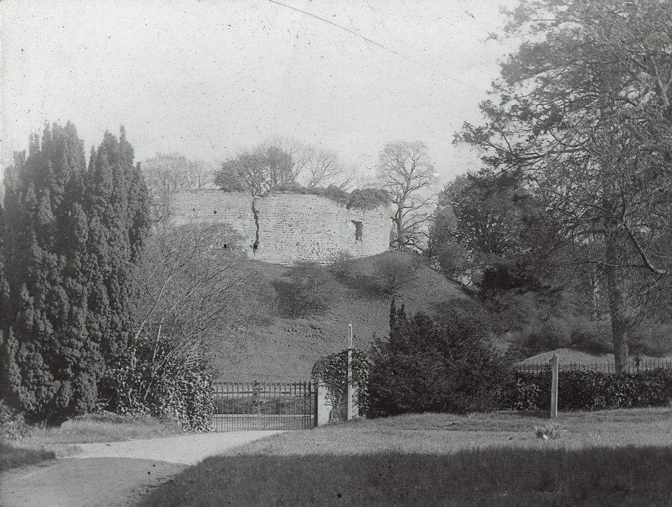
The castle in 1900 from the churchyard. Source: the MacLeod archive

4076554724_b6df6c95d4.jpg

The castle from Mitford Bridge, 1840s. Sourced from the Alnwick Mercury of 02/02/1857

bottom of page