Havelock Place, Backworth
Backworth, North Tyneside
Last Updated:
21 Nov 2024
Backworth, North Tyneside
55.051201, -1.535227
Site Type:
Settlement
Origin:
Status:
Demolished
Designer (if known):
Now a walking trail to Seghill

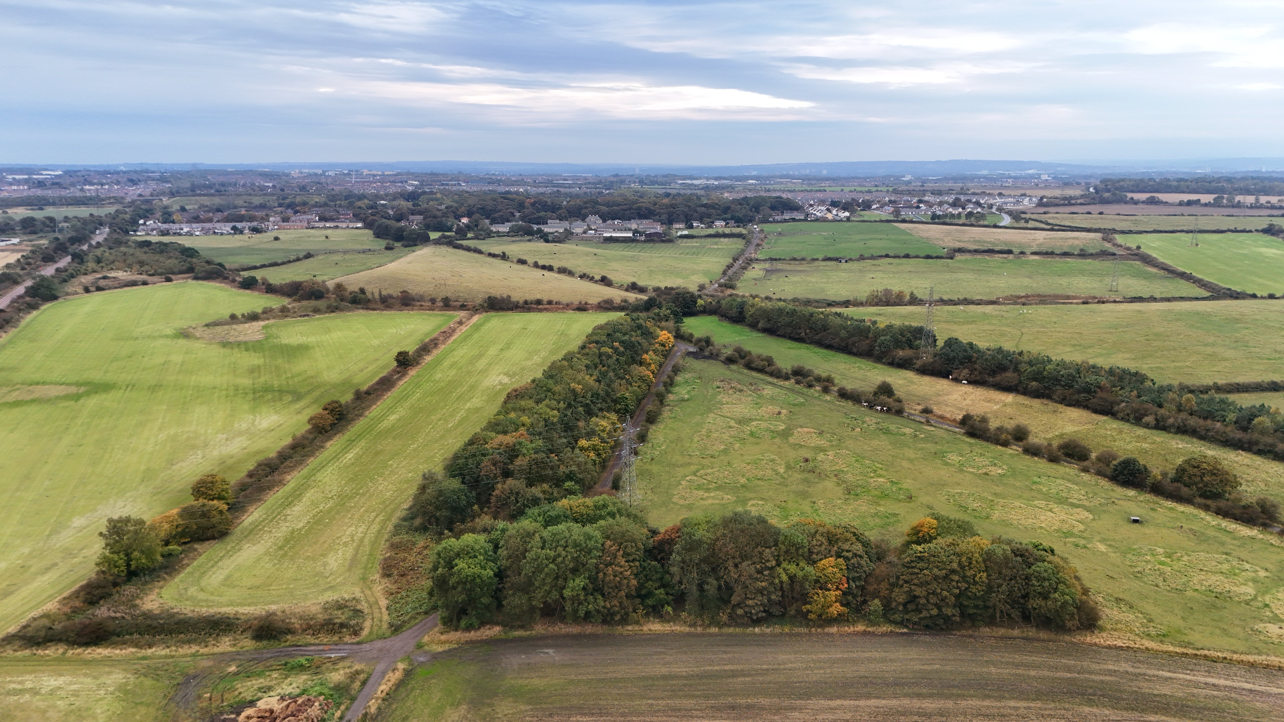
If anyone has ever walked between Backworth and Seghill, you'll definitely recognise this path. It's just off the old Backworth Colliery sites.
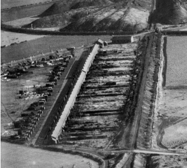
This was one of the long forgotten pit communities in these parts - Havelock Place. Havelock Place was a triangular settlement with 2 separate rows of housing facing the central field you see on my aerial shot. They were almost certainly built in the 1850s after the revered (and controversial) Henry Havelock, born in Sunderland rising to become one of the foremost generals in the British Army. Nowadays, he's associated with the brutal suppression of Indian rebels, though it would be unwise for me to discuss this event on this post... Backworth C Pit was also sunk in 1856, which gives credence.
The community was made up entirely of pitmen and their families working at the Backworth Pits and the Hotspur Brick Works. A quick peruse over the census records confirms this - with inhabitants working as "fire brick labourers", "brick moulders", "blacksmith at brick works" and coal hewers.
Though the houses were solidly built with bricks made adjacent, the infrastructure was less sturdy. A United Free Chapel stood here, but children had to walk across the muddy, sodden trails to Backworth each day. Vehicles and wagons struggled to get through and requests were made in the 20s for the coal company to re-ash the lane. There were regular floods due to bad drainage alongside regular outbreaks of illness - Diphtheria and Measles outbreaks are both mentioned. With this said though, I'd be keen to hear from former residents on what this place was actually like.
The above reasons were contributors to its clearance. Havelock Place disappeared in the late 1930s, with residents rehoused on the nearby Moorside Estate. Nowadays, at certain times of the year you can still see the blooms of the garden flowers and bits of rubble from this old street.
Listing Description


Both Ordnance Surveys shown depict Havelock Place throughout the latter half of the 19th century. We see it on the first map around a decade after the houses were built, supplementing the accommodation needed for pitmen & their families working at the C Pit and West Holywell Colliery. At this time there were few facilities apart from each dwelling having an outhouse, and the lucky west side having a garden. To reach any sort of post office, chapel or school, they had the choice of walking south to Backworth or West Holywell. Or, they could travel to the larger settlement of Seghill where there was a national school, 2 Methodist chapels and a Post Office.
The 1890s map details the addition of a United Free Chapel and the Hotspur Brickworks. West Holywell Colliery had closed by this stage, so men had either swapped occupations to working at the brickworks or relocated to the C Pit.

The Ordnance Survey of 1920 illustrated Havelock Place now bordering the Burradon & Holywell Waggonway over to Burradon Colliery, as well as the addition of a Good Templars Hall. The Good Templars were a fraternal temperance organisation, promoting the removal of alcohol and drugs from lifestyles. They were common in mining communities as these ideals were pushed by colliery managers for a more productive workforce. Such strict ideals also conformed to the pious faith of many locals.

Havelock Place looking south to Backworth in October 2024

The east side of Havelock Place in 1938, just before demolition.
Source: © Historic England. Aerofilms Collection EPW059726 flown 5 October 1938

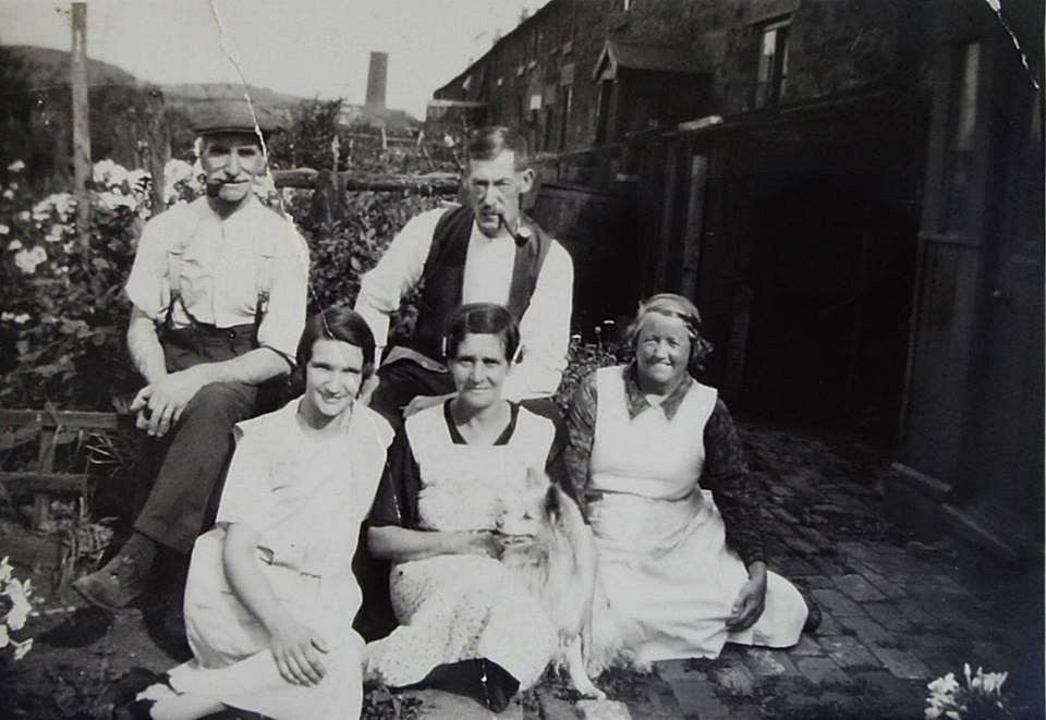
An unknown photograph taken at Havelock Place from the 20s or 30s. This photograph gives us a good idea of the construction. We see the brick-floored backyards and the back porches. It looks like this is the eastern row, given the chimney in the background which may be from the C Pit.
Unknown original source.