Seaton Delaval, Northumberland
Dairy House, Seaton Delaval
Last Updated:
11 Dec 2022
Seaton Delaval, Northumberland
This is a
Farmstead
55.071951, -1.495500
Founded in
Current status is
Demolished
Designer (if known):

No evidence remains of the farmstead though potential earthwork remains.
'Dairy House, a farmstead which has long disappeared from the landscape, was located close to the point where the waggonway from Hester Pit (New Hartley) curved sharply from its south-easterly course to pursue a north-easterly route towards Seaton Sluice. It is possible that trains on the waggonway between Hartley Pit station and Seaton Sluice called here, but there is no firm evidence that they did.
When the Blyth & Tyne’s Avenue Branch opened, it followed the waggonway’s route from the new (2nd) station at Hartley as far as Dairy House, where there was now a junction - the Avenue Branch continuing straight ahead to Whitley, whilst the Seaton Sluice waggonway curved away from it. The opening passenger timetable of the Avenue Branch (1 April 1861) included Dairy House as the only intermediate station. Some months later The Avenue replaced it in the timetable. There is no compelling evidence that a station was ever built at Dairy House, the only hint being a broadening of the railway property on the north-east side of the Avenue Branch single track immediately north of the divergence of the waggonway to Seaton Sluice, as shown on the 1:2,500 map of 1865. It could be that the name Dairy House was given in error to The Avenue station (only half-a-mile north) and that the change of name in the timetable was a correction; but why would the name of Dairy House have appeared, even briefly, if passenger trains had never called there?'
- Disused Stations
There is no longer any trace of the dairy house, though the alignment between The Avenue and Seaton Sluice still remains. A potential earthwork can still be seen that corresponds with the site at 55.071951, -1.495500, showing potential archaeology underneath the soil.
An article from the London Gazette of November 1866 discusses the Avenue House and Dairy House in particular:
"The whole, of the lands upon which the Dairy House and Tynemouth Branches of the said Blyth and Tyne Railway have been constructed from the commencement of the said Dairy House Branch, near Hartley Station, in the parish of Earsdon and township of Seaton. Delaval, to the termination thereof near the;Dairy House, in the township of Hartley; 'in the parish- of Earsdon, lands being situate in the following townships, parishes, or places following, that is to say:—Earsdon, Seaton Delaval,. and Hartley, or some of them, all in the county of Northumberland, and from the commencement of the Tynemouth "extension, at or near the Dairy House aforesaid to the termination thereof, at or near to the Tynemouth Station, in the parish and township of Tynemouth, such lands being situate in the following parishes, townships,, .or places, that is to say :—Earsdon,, Seaton Delaval, Hartley, Holy well, Tynemouth, Whitley, .Monkseaton,. Chirton, Preston, C.ullercoats, and North Shields, all in the said county of Northumberland."
Listing Description (if available)


Above are the Ordnance Survey maps from both 1865 and 1897. The 1865 map further above illustrates the Dairy House farmstead, neighbouring the waggonway to Seaton Sluice and a number of old coal shafts on farmland. The branch was only a single line, and as noted above earlier had carried passengers, though evidence of a platform or station building is negligible.
The 1897 map shows a smiliar picture though the waggonway to Seaton Sluice is lifted by this point. The number of old coal shafts are still shown and the single line Avenue Branch is still operating taking travellers to Monkseaton and the like.

The map of 1820 shows the Dairy House but a reduced size. Potentially either an admin error or the farmstead was either left in situ after use and partly demolished. The Avenue line is still in use, and the old waggonway is labelled on this map. In fact, the alignment of the waggonway can be still seen if you go on a walk down to Holywell Dene. Little else has changed in this respect, though the line i a local footpath.

Aerial view of Dairy House farm, 2022. The foundations of the farmstead are visible from above, though the features are non-descript. The waggonway alignment can be seen adjacent.

Another perspective of the farmstead which had been demolished in the latter half of the 19th century.

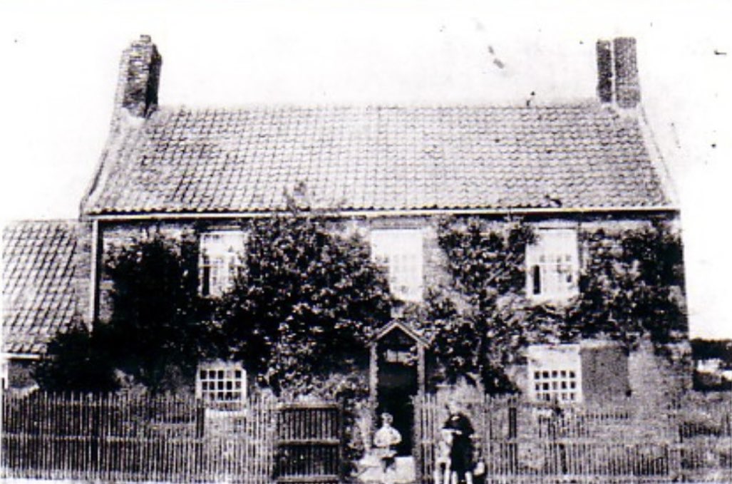
The only surviving photograph of the Dairy House around the 1900s. The farm buildings are immediately to the right. The house was demolished by fire in 1928. Unknown original source.
