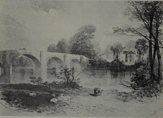
Chollerford Bridge
Chollerford, Northumberland
Last Updated:
16 Jun 2024
Chollerford, Northumberland
55.029309, -2.127426
Site Type:
Bridge, Crossing
Origin:
Status:
Extant
Designer (if known):
Robert Mylne
Listed Grade II

One of the most beautiful landscapes along the North Tyne, and one of the oldest crossings on the river.
This is the Chollerford Bridge. It opened in 1785, just a few years after the Great Flood which swept away all but one bridge on the Tyne at Corbridge. Its previous iteration was of medieval origin, first mentioned in 1333 when Brishop Skirlaw of Durham granted indulgence (ie remission of sin) if folk were to contribute to its repair. The bridge featured four arches and was in dereliction by the 1710s - "very dangers" the Grand July at the Northumberland Sessions put it.
The current iteration features 5 arches, with the great Robert Mylne the engineer. He was also the engineer for Blackfriars Bridge & Addington Palace in London, the old stone Tyne Bridge and Hexham Bridge. His prominence highlights the importance of this bridge strategically and logistically, given it was on the Military Road east and west. It also appears he was the engineer envisioned to rebuild the Tyne crossings across the country.
Traffic is a little more sparse these days given east-west traffic cuts north of Hexham, but we're lift with a magnificent structure fit for its surroundings.
On the right of the main photograph, you may also notice some documented medieval ridge and furrow at the bottom of the shot. You lot might call it rigg and furrow, but these are wave-like ridges caused by centuries of ploughing. You can read more about this specific site here here: https://www.heritagegateway.org.uk/Gateway/Results_Single.aspx?uid=1447724&resourceID=19191
Listing Description


These Ordnance Survey maps present Chollerford through the latter half of the century. Like most areas in these parts there's limited change through the decades. This was of course a time when Chollerford featured its own railway station along the Border Counties Railway. There was a second pub at Chollerford - the Red Lion in a small 2 property terrace near Waterside Farm, and this structure still exists.

Interesting, the piers of the old bridge were still extant on this map in the 1920s, though it appears they have since been removed unless they are only visible on low tide. Otherwise, here we see the largest extent of the George Inn which I discussed here: https://x.com/neheritagelib/status/1801659636992324041

Aerial photograph of Chollerford Bridge in 2024

The Chollerford Bridge and George Inn in 1948. Source: © Historic England. Aerofilms Collection EAW017444 flown 24 July 1948

A relatively little known illustration of the George Hotel and Chollerford Bridge in 1839, by Thomas Miles Richardson.