Allendale Railway Station
Allendale, Northumberland
Last Updated:
9 Dec 2024
Allendale, Northumberland
54.907348, -2.264199
Site Type:
Railway Station
Origin:
Status:
Partly Preserved
Designer (if known):
Now a caravan site

The station, first known as Catton Road railway station, opened in 1869 a few months after the line opening, as the terminus for the Hexham & Allendale Railway. Previous to this, Haydon Bridge was the main connection to the outside world with the roads being the dominant arteries to move lead and people. The intention was for the railway to open up the whole region with the bigger towns and cities. The line was 12 and a half miles, connecting the small hamlets, settlements and industries with Hexham. It also allowed coal to be easily shipped in for the smelters and communities, bringing down prices.
The line was supposed to creep further southwards to Allenheads. Enthusiasm was great with the NER subscribing £10,000 and received an act of parliament. The hilly terrain would require picking apart the landscape like play-doh with cuttings, curves and gradients which were punishing. Therefore, Catton Road just short of Allendale remained the terminus.
Catton Road station was modest. The existing house is made of uncoursed stone, with the station platform made of similar material with a wooden extension in 1884. There was a turntable, creamery and a small goods yard alongside the branch to the Allen Smeltery.
Traffic here and at Staward, Langley and Elrington was always pretty dire. Allendale received the most, but only ever reached the tens of thousands annually. Buses were cited as the problem as they could run directly into the village centres, and ironically ran by a subsidiary of LNER. Passenger services ended in 1930 with goods services including a parcels offering closing 20 years later.
Nowadays we see the station house, platform and station boundary as a reminder of what once was.
Listing Description


The Ordnance Survey maps here illustrate the station site between the 1890s and 1910s (though the map was published in the early 20s). The railway hugged the bottom of the valley which is why the line appears to lead west rather than east back to Hexham. It required some proper solid engineering (as seen by the lovely stone culvert over at Catton Lea (https://x.com/neheritagelib/status/1857699832925749274) to even get this far, and gives credence as to why it wasnt extended. On the 1890s illustration we see the single track line leading to the single platform, goods shed and the round turntable alongside the branch leading to the smelting mill. This led under the road on a short gradient over the river East Allen.
As you can see by the 1910s though it closed at the turn of the century and the line was pulled up leaving Allendale a proper terminus. A creamery opened up though which will surely have used the railway to deliver milk up to Hexham for wider consumption.

This is the area a decade before the railway was opening in 1859 (though published in 1865). There's no trace of any lines at all, and travellers made do with horse and cart as well as industry. The smelting mill will have had a rough time delivering product over the fells to Haydon Bridge, which was the main delivery point before the railway.

An aerial overview of Allendale Railway Station in November 2024. The boundary of the line can still be seen heading west, circumventing the core of Catton and instead leading to Bishopside. Today we see the station house and adjacent creamery still in situ.

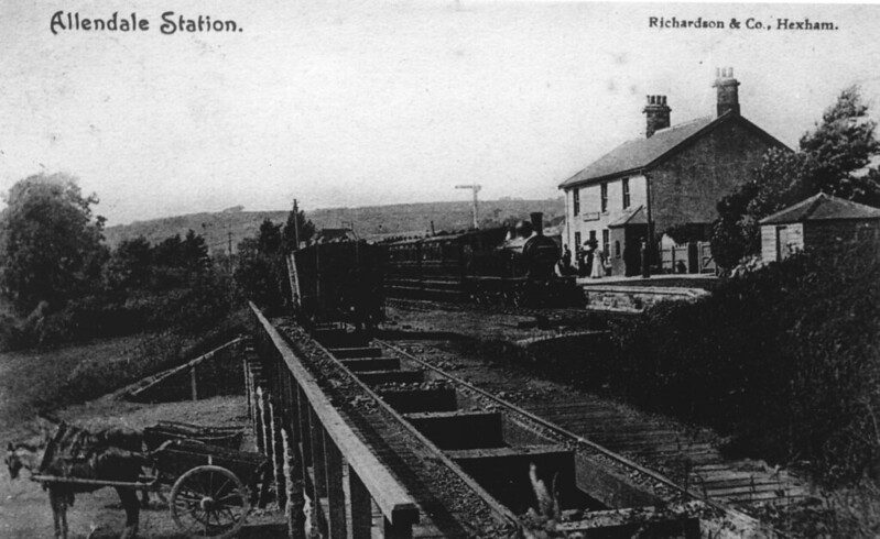
A view of Allendale Station, with the coal drops in the foreground and carts no doubt waiting to take coal to Allendale. A service is just pulling in from Hexham. Source: Allen Valley Local History https://www.allenvalleyslocalhistory.org.uk/photo/catton-0002-098/

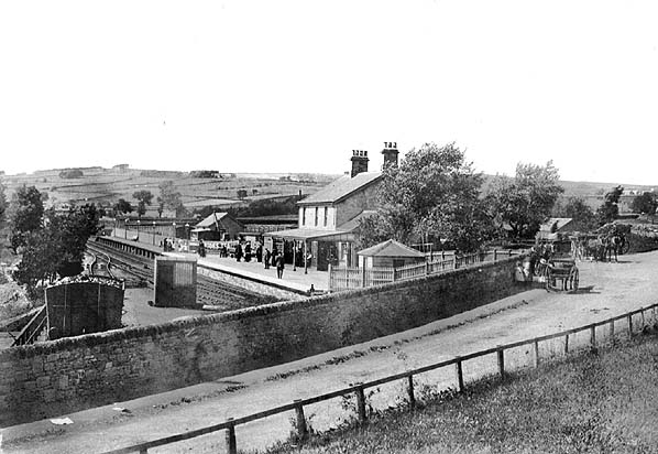
Allendale Railway Station around 1914. The turntable is just obscured by the stone wall, but the coal drops can again be seen where the wagon is situation. Source: Allen Valleys Local History https://www.allenvalleyslocalhistory.org.uk/photo/allendale-1914-0031-005/