top of page

Allendale, Northumberland

Allen Smelting Mill & Flue System

Last Updated:

6 Dec 2024

Allendale, Northumberland

This is a

Smelting Mill, Flue System

54.903626, -2.263950

Founded in 

17th century

Current status is

Partly Preserved

Designer (if known):

4076554724_b6df6c95d4.jpg

Designated Scheduled Monument

In the rolling hills of Allendale you'll find its core industry - the industry that propped up the whole area. Lead. The site outlined below was the principal works in the whole region which brought prosperity to the hills.

The Allen Mill builds upon a lead working site which as stood here since the late 17th century. At this time, the Bacon family will have smelted lead to be used for houses, ammunition and any sort of lining really. This continues through to the 18th century when it was to Sir William Blackett, who leased it out to local mineowners to smelt their own ore. Along with coal this was the industry which expanded the family fortunes, with their influence growing to such an extent their name is still known across the NE. This was even despite great fluctuations in the lead industry in the early 18th century.

It formerly came under the ownership of the Beamonts, Wentworths, Fenwicks and Blacketts in 1786 - all famous North East names. It was them who rebuilt the complex we see below in the 1830s to include 5 roasting furnaces, 8 ore hearths, a refining furnace, 2 reducing furnaces, 2 calcining furnaces, 2 reverbatory furnaces and a slag hearth. Don't ask me what half of those mean, but the key point is it was the key player in the prosperity of this whole area and production vastly expanded in the 19th c.

In fact, if you take a closer look on my first aerial shot you can see extensive remains of the 1830s works. These are reputed to be "bouse teams", which as far as I am aware are big storage hoppers where material was kept before sorting. There is also a condensing champer and a flue opening which is still extant.

In the late 1860s it was connected to rail, and effectively kept the Hexham and Allendale Railway going until it met its own demise. Slumps in lead prices appear to have been constantly fluctuating, and put the whole railway and the works in constant instability.

By the end of the 1890s, the works was no longer viable. In 1852 their world famous mines had an output of over 10,000 tons, more than the whole of the north at the turn of the 20th century. Waggons, stores, tools, stock and machinery were all part of a firesale in 1899 to get rid of all the assets which must have left the families in real embarrassment.

Nowadays this site is an office park.

FLUE SYSTEM

Of course, any dealings with lead are incredibly toxic. The firm took great lengths to transport the noxious fumes to high positions to release the fumes away from lower ground. The fells around here made for ideal sites to exhaust it, but how did it get there?

Well, they constructed giant flue systems from the 1830s to the 1850s, which were basically giant pipes built using cut and cover. There's evidence of these pipes all across the area that look like giant worms have excavated under the surface. Here's two examples at Thornley Gate and Langley.

The flues were hot, dingy, dangerous places. They were cleaned by the mill workers as dust stuck to the linings and could be recycled back in the mill. Children weren't employed by the mill but experienced and hardy, but sadly expendable men.

Despite the efforts of these flues the surrounding land was still contaminated leaving the land sterile.

Listing Description (if available)

The monument includes the remains of part of an ore hearth smelt mill and a reverberatory smelt mill, as well as the extensive system of flues which includes two chimneys, several ramped access ways and part of a contemporary trackway. It is in six separate areas of protection. The smelt mill is situated on the valley floor on the south side of the River East Allen; the flues emerge from the rear of the smelt mill and run in a south westerly direction to the open fells above, terminating in a stone built chimney near the watershed at Flow Moss approximately 3.5km away. Ore smelting in Allendale is well documented and a smelt mill is recorded in AD 1692 which belonged to the Bacon family. During the 18th century the smelt mill was leased from Sir William Blackett by Lancelot Algood who used it to smelt ore from his Alston Moor mines. From 1786 the mill was owned by the Beaumont Company which, during the 19th century, carried out improvements to the smelt mill. In 1847 a document and an accompanying plan of the mill shows that there were five roasting furnaces, eight ore hearths, a refining furnace, two reducing furnaces, two calcining furnaces, two reverberatory furnaces, one slag hearth and a separating house with 18 pots. The Allen smelt mill ceased production in 1896. Much of the smelt mill has been levelled, but a broad retaining earthen bank at the rear of the smelt mill site contains the remains of several stone structures revetted into the slope. Some of these structures are interpreted as the remains of a series of bouse teams located either side of the main flue; they are visible as stone walls standing 5m high with buttresses forming the individual bays. Some of the other structures contained within this area include the remains of a condensing chamber and a flue opening. The flue opening consists of a stone arch 1.5m high and 1.5m wide and a tunnel which it is known runs for some distance into the slope; side flues run to the east and west of the main flue. The smelt mill originally extended over a larger area down to the river. Only that area in which significant archaeological remains are known to survive is currently included in the scheduling. A structure lying on the north side of the smelt mill complex and known as the Pattinson Building still stands. It was a 19th century silver smelter in which silver found in association with the lead was refined. The ground level flues, which run between the smelt mill furnaces and their chimneys, were constructed during the 19th century. Their prime purpose was to condense the noxious fumes produced from the furnaces; the deposits, which formed as a result of this process on the internal walls of the flues, were periodically removed and their lead and silver content retained. Before the development of ground level flues, this valuable silver deposit would not have been recoverable. The smelt mill flues also removed the noxious gases away from settlements within the valley to a more remote area. Work on the flues is thought to have taken place in at least two separate phases. The first flue, which was begun in 1808, runs from the south end of the smelt mill and follows the south side of the B6295 before turning west towards Cleugh Head where it originally terminated. On construction of the second flue in 1853 it is thought that the first was extended south and then south west to Flow Moss. The second flue emerges from the south western side of the smelt mill and crossed over the adjacent road on what is thought to have been a bridge; on the western side of the road there is a substantial flat topped platform some 6m by 18m which is interpreted as a structure associated with this bridge. The flue continued south west on a more direct route to the chimneys on Flow Moss. The remains of the flues are visible in various forms: where they survive intact they are visible as linear mounds up to 8m wide standing to a maximum height of 2m. Internally, they comprise an arched structure constructed of square masonry which also lies below ground level for some 2m to 3m. Where the roofs and upper levels of the flues are no longer intact they are visible above ground level as a ditch on average 2m wide and 0.5m deep, flanked by two parallel mounds 2.5m to 3m wide and standing up to 1m high. In some areas the upper parts of the flue walls have become spread to form an earthwork on average 10m wide. The remains of at least seven doorways giving access to the interior of the second flue are visible in its upper 2km. These entrances would have given barrow access to remove the condensed lead and silver from its walls. Each of these access points is visible as a hollow road up to 4m wide and as much as 17m long, which generally runs parallel with the flue. The road ends in a concave walling and a ramped entrance into the flue. One of the ramped access points near to Frolar Meadows is unusual in lying at right angles to the flue, which at this point is also flanked by a trackway, thought to be an original access route. Only those parts of the flues which survive well are included in the scheduling. There are two chimneys on Flow Moss. The most southerly chimney, into which both flues pass, has undergone consolidation, and is visible as a well preserved structure 7m in diameter. It is built of regular sandstone blocks and was formerly higher than its present 6m. There are two arched flue openings at its square base with the remains of mortice holes. A fragment of a central dividing wall is visible within the chimney. The most northerly chimney, approximately 40m north of the first, stands 25m high and 4m in diameter, and contains a single arched flue opening; the earliest flue bypasses this chimney in favour of the second, although traces of an earlier course to it are visible as a slight earthwork.

Both Ordnance Survey maps shown here illustrate the Allen Smelting Mill from the 1850s until the eve of its closure in the 1890s. You'll notice it was without its rail link in the 1850s as the Hexham & Allendale Railway was yet to be constructed. Product was likely shipped via horse and cart up to Haydon Bridge or Hexham. You'll see the dashed lines indicate the embankments of the flue systems, with both leading south to a chimney on Flow Moss. The flue started across the road and was taken overhead by a pipe across the road which then leads underground, with a second flue leading up to Thornley.

The 1890s map depicts the works with the branch extending from Catton Road Station, the terminus of the Allendale Railway. Wagons were shunted from an end siding into the complex, probably only fitting around 10 or so at a time.

The 1921 Ordnance Survey illustrates the mill some 20 years after closure. The railway line was severed and the shunt sidings reclaimed as a plantation. Many of the structures are intact as they are today, though many have slowly been demolished over time. The flue system is exactly as it is today.

4076554724_b6df6c95d4.jpg

Site of the Allendale Smelting Mill in November 2024
4076554724_b6df6c95d4.jpg

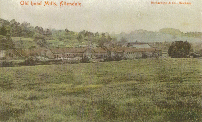
The Allen Mill in the 1890s. Source: Allen Valleys Local History Group

4076554724_b6df6c95d4.jpg

The flue system leading through Thornley Gate in November 2024

bottom of page