365b
Usworth Colliery
Usworth
54.920018, -1.509238
Wellington Pit
Opened:
Closed:
1845
1974
Entry Created:
3 Sept 2021
Last Updated:
18 Jul 2023
Reclaimed
Condition:
Owners:
G. Elliott (1845), J Johansson, Sir George Elliott (1840s), John Bowes & Partners Ltd. (1882), Johansson, Gordon & Co. Ltd. (1990s), Leverson's Wallsend Collieries Ltd. (1910s), Washington Coal Co. Ltd. (1940s), National Coal Board (1947)
Description (or HER record listing)
There were three pits: Frederick (1815-1914), Victoria and Wellington (1845-1974). Owners were George Elliot, then J Johansson and Sir George Elliot, 1882 John Bowes & Partners, then Johansson, Gordon & Co Ltd, then Leversons Wallsend Collieries Ltd, 1940 Washington Coal Co Ltd and 1947 National Coal Board.
O.S. maps show a large settlement, with terraces of houses round two 3-sided squares, Post Office, two chapels, a school (built 1863 for 600 children), miners' hall (substantial brick building built in 1891 at a cost of £1800, including a lecture hall, reading room, billiard room, community room and caretakers house), spoil heaps and mine buildings, all immediately east of Little Usworth, and a wagonway going ENE to join the NER Newcastle, Leamside, Ferryhill Line.
There was an explosion on 5 June 1850 which killed 13 miners and another on 2 March 1885 which killed 42. There is a memorial to the victims in Holy Trinity Churchyard in Donwell. In 1890 the engine house was destroyed by fire.Whellan reports that in 1894 the colliery produced 1000 tons a day and employed 750 men and boys.
In 1959 the colliery was joined to Follonsby Colliery (HER 6942) by an underground loco road. Maudlin seam abandoned 1954. Brockwell seam abandoned 1914.

Ordnance Survey, 1896

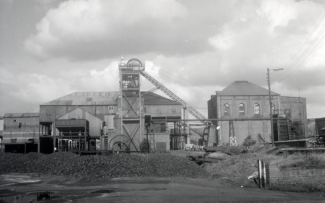
Usworth Colliery in 1965. Source: Tyne & Wear Archives
Have we missed something, made a mistake, or have something to add? Contact us

Usworth Colliery in the mid 60s just prior the New Town developments. Source: Sunderland Libraries
Historic Environment Records
Durham/Northumberland: Keys to the Past
Tyne and Wear: Sitelines
HER information as described above is reproduced under the basis the resource is free of charge for education use. It is not altered unless there are grammatical errors.
Historic Maps provided by

