Jesmond Parochial Hall
Jesmond, Newcastle
Last Updated:
7 Mar 2024
Jesmond, Newcastle
54.994708, -1.602325
Site Type:
Parish Hall, School
Origin:
Status:
Extant
Designer (if known):
Thomas Ralph Spence
Listed Grade II

This is the absolutely stunning Parochial Hall next to St George's. The whole area is one of the most complete 19th century urban landscapes in Newcastle, and this area tops it off.
Despite giving the impression of a centuries old Gothic church, it was actually built in 1887 as the parish hall and school to the adjacent St George's. It was part of the wider square funded and gifted to the area by shipbuilder Charles Mitchell, replacing a tin tabernacle on the site.
The hall itself however was opened by Mr Mitchell, but funded by parishioners with Henry F Swan, the managing director of Mitchell's yard, the chairman. Upon opening the hall held 400 people, with smaller classrooms on the site and furnished with Austrian bent-wood chairs.
The architect was Thomas Ralph Spence, an acquaintance of both Mitchell and Armstrong. His primary vocation however was as a painter and metalworker, so this is one of his only works.
Listing Description


The Ordnance Surveys of the 1890s and 1910s both illustrate the Parochial Hall opposite St George's and the Vicarage. The 1890s map shows the Hall only a few years after its construction, just as much of the Jesmond housing developments subsided. The area was already copious with villas and large houses, such was the appeal of the area. At the same time, the tramway had reached the north end of Osborne Road, certainly appealing to churchgoers.
The 1910s map presents a similar a vista, though in better view is the cricket ground opened by the 1890s.

We can turn the clock back further though, to when much of Jesmond was a rural oasis with large mansion houses dotting the landscape. Our site appears to be part of the West Jesmond House grounds, residence of the brewer T W Lovibond according to the HER. Read development started around the 1870s and reached its epoch in the 1880s.

The Parochial Hall in 2024

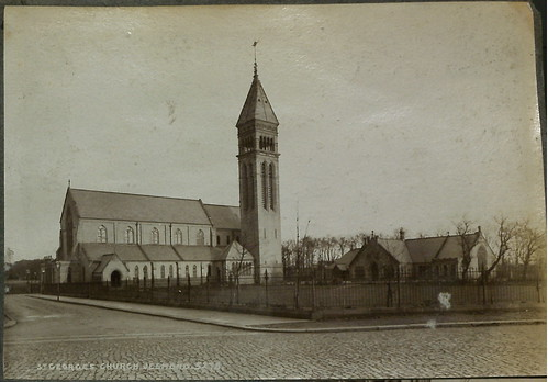
I love this photo, taken just before the typecast Jesmond terraces encroached this far up. They were only built a few years later, and ever since the view is rendered impossible. The Vicarage is a handsome building too. The Parochial Hall can be seen on the right.
Source: Newcastle Libraries

The hall to the left of the church. Source: Newcastle Libraries