The Bridge Hotel, South Shields
South Shields
Last Updated:
19 Jan 2024
South Shields
54.998556, -1.433727
Site Type:
Pub
Origin:
Status:
Extant
Designer (if known):
Locally listed

This site on King Street was both a pub and a railway station.
No. 30 was built as the Bridge Hotel - a name which has cemented this ground since 1834. It was renamed in this year from the Kings Head, as the Stanhope & Tyne Railway made its way over King Street to the drops on the river.
Before this pub was rebuilt in the 1890s, and before the station at Mile End Road was built, folk would buy their tickets from the back room and make their way up to the coal depot on Salem Street. From there, they would board carriages at the depot. Given it was a public house, it likely provided refreshment and a comfortable space for passengers awaiting departure.
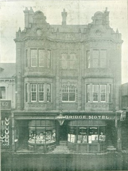
As noted, this pub was rebuilt in the late 1890s with this beautiful ornate terracotta coloured stone. Gargoyles and relief tiles line the storeys with even the back fairly attractive with its white lined tiles. It was for sale by private tender in 1902, giving us a great insight into the interior. It comprised a long bar, two select rooms on the ground floor with an 80ft long cellar below. There was a buffet bar on the first floor as well as a large smoke room. On the second floor there were five rooms for management, and adjoining the bar a large shop and offices above.
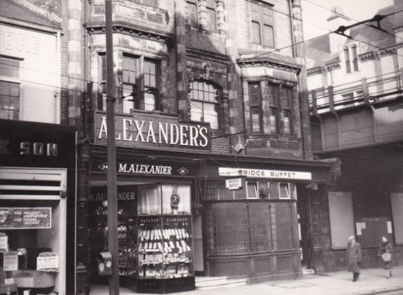
The Newcastle Breweries pub and its buffet closed in 1973, and has since become two separate units. Betfred closed last year.
Listing Description


Both Ordnance Survey maps above illustrate King Street and the surrounding area from the 1850s through to the 1890s. The pub itself was much smaller in the 1850s, with an extension constructed some time in the next few decades. It is around this time that it was used as a railway station building, with passengers making their way through the rear to the coal depot directly opposite. The bridges over King Street and Smithy Street were both timber constructions, subsequently rebuilt in later years to their more modern iron iterations. Many of the buildings seen on the 1850s map have been demolished, with King Street composed mostly of 3+ storey buildings from the 1870s or later.
The 1890s map depicts a far longer Bridge Inn, with the coal depot on Queen Street becoming a smithy after the construction of South Shields station in 1879.

The Ordnance Survey map of 1915 shows the Bridge Inn (Hotel) next to the railway line (labelled PH). This is after the rebuild and long after any use as a station building, though with no doubts travellers stopped here for a quick refreshment before or after travel. The pub was to remain open for another half century.

The Bridge Hotel, 2023

An advert from the 1900s. Source: South Tyneside Libraries, South Shields Local History Group

The buffet in 1961 - the pub entrance was at the rear. Source: Roy Lawson, Sunderland Antiquarian Society, South Shields Local History Society